Types of landmarks by relief
Any unevenness of the earth's surface can be a guide.
Of all the known forms of relief for orientation, it is most convenient to use elevated forms; they are clearly visible landmarks.
Landforms can be used as area, point, and linear landmarks. Large landforms, such as plains, mountain ranges, and huge mountain slopes can be used as area landmarks.
It should be noted that flat shapes (plains, lowlands, river valleys) can be a guide, but they are less convenient to use compared to elevated ones.
Linear landmarks of the relief are narrow valleys, hollows, ravines, gullies, dunes, dunes. They can help you keep the right direction while moving.
Expert opinion
Tarasov Dmitry Timofeevich
Master of Sports in mountaineering. Author of scientific articles on the topic of survival in the wild
Small landforms can be point landmarks. They can be hills, rises, holes, stones, depressions, dry river beds, dry lake basins, high areas of river banks, loose stones, etc.
Determining the sides of the horizon based on landforms
The northern slopes of elevated landforms are more moist, snow lies on them longer, they remain wet longer after rain and warm up worse. There are more lichens growing on the northern slopes of the mountains.
During hot summers, the northern slopes are covered with richer grass cover, while the southern slope has less grass. There are more coniferous forests on the northern slopes of the mountains.
Cold-loving vegetation grows on the northern slopes. On the northern slopes the border of forests and the snow line is lower than on the southern ones.
Large stones lying separately can also be landmarks. On the northern side they are colder and remain wet longer after rain. On the north side the stones are covered with lichens.
On the south side, individual stones are warmer and dry out faster after rain. The southern part of the stones is drier. In spring, snow melts faster on the south side.
The same pattern can be seen on large landforms. In spring, southern slopes are cleared of snow faster.
On the southern slopes of mountains and hills, the formation of thawed patches occurs the faster, the greater the steepness of their slopes. The southern slopes of mountains and hills are warmer and drier than the northern ones.
They are more strongly eroded by spring waters, as snow melts more intensely and fast flows of water erode the slopes. More gullies and ravines form on them.
There is little turf on the southern slopes. Often the southern slopes are covered with grass, and the northern ones with coniferous forests. Heat-loving and dry-loving plants grow on the southern slopes of mountains and hills. Each slope has its own plant community.
If you study it, you can determine where you are and can easily find the direction north and south. On the southern slopes the border of forests and the snow line is higher than on the northern ones.
Expert opinion
Tarasov Dmitry Timofeevich
Master of Sports in mountaineering. Author of scientific articles on the topic of survival in the wild
In areas with permafrost on mountainous or hilly terrain on southern slopes, snow melts faster and the soil thaws deeper. Wetlands form on the northern slopes. The northern slopes are covered with mosses.
Soil orientation
This is interesting: Orientation on the terrain without a map. The essence of orientation
The soil does not warm up equally on the north and south sides. This feature can be a certain guideline.
The soil on the north side near hills, stones, buildings, trees is always more moist and colder. On the south side the soil is drier and warmer.
On the southern slopes of mountains and any elevations, thawed areas form faster than on the northern ones. The snow mass seems to be ruffled by many thawed patches. The steeper the slopes, the faster the formation of thawed patches.
Landmarks in the mountains are mountain peaks and gorges, mountain slopes and rivers, waterfalls and lakes, forests and meadows, glaciers, etc. The influence of constant winds in the mountains can be judged by the destruction of rocks, their condition, soils, and vegetation characteristics.
In the mountains on the windward side there is more destroyed rock. The winds make many parallel furrows on the surface of the mountain slopes, sometimes creating niches with overhanging canopies and cornices made of hard rock.
On the windward side, winds blow away the soil cover, it is thin or absent. If a mountain slope faces the sea and constant winds blow from it, then this slope will receive more precipitation. It will be more hydrated. Landslides occur more often here.
Vegetation on windward slopes usually slopes in the direction of the constant winds. Sometimes, due to constant winds, tree crowns are shaped like a flag and tilted in the direction of the winds.
On the windward side, wooden buildings change color faster and collapse much faster compared to buildings on the leeward side. More snow accumulates on the leeward side.
The nature of the slopes and their vegetation are important signs for orientation. Southern slopes are often much drier and warmer and, accordingly, a different complex of plants develops on them than on northern slopes.
It is not uncommon for the southern slopes to be covered with grass, and the northern slopes to be covered with forests. The southern slopes are inhabited by more heat-loving and dry-loving plants.
Each mountain region has typical plant communities of northern and southern slopes. Examine the vegetation carefully and then you will be able to determine which slope you are on.
In the mountains on the southern slopes, the tree line and snow line are in most cases higher than on the northern ones.
Geography lesson in 5th grade taking into account the requirements of the Federal State Educational Standard
Preview:
Outline of a geography lesson in 5th grade, taking into account the requirements of the Federal State Educational Standard.
- Full name of the author: Igonina Nadezhda Anatolyevna
- Place of work: Municipal educational institution secondary school No. 2, Krasny Kut, Saratov region
- Position: teacher
- Subject: geography
- Class: 5
- The topic of the lesson and the lesson number in the topic: Orientation on the earth's surface. (lesson
No. 12 in section No. 3 “Geographical models of the Earth.”)
- Basic textbook: “Geography. Geography. 5-6 grades", authors: V.P. Dronov, L.E. Savelyeva, M. Bustard, 2012
- Purpose of the lesson: To develop skills in orienting on the earth's surface using a compass and using local signs.
Educational: to reveal the content of the concepts of “terrain orientation” and “sides of the horizon”, “azimuth”, to teach techniques for determining the sides of the horizon using a compass and local signs, and walking in azimuth.
Developmental: expand knowledge about instruments and methods of orientation, highlight the difference between the main and intermediate sides of the horizon.
Educational: to promote the formation of a geographical culture, the development of the ability to work in a group, team.
Personal: formation of terrain orientation abilities;
Meta-subject: the ability to organize one’s activities, determine its goals and objectives; ability to interact in pairs and groups, to work with a compass; make judgments, supporting them with facts.
Expert opinion
Tarasov Dmitry Timofeevich
Master of Sports in mountaineering. Author of scientific articles on the topic of survival in the wild
Subject: the ability to use orientation skills to determine one’s position in space using a terrain plan, compass and topographic map.
Personal: realize the need to study the world around us. Regulatory: plan your activities under the guidance of a teacher, evaluate the work of classmates, work in accordance with the assigned task, compare the results obtained with the expected ones.
Cognitive: analyze, compare, classify and generalize facts and phenomena, identify the causes and consequences of simple phenomena, process information to obtain the desired result. Communication: the ability to communicate and interact with each other.
12. Lesson type: lesson of “discovery” of new knowledge.
13. Forms of student work: individual, group, in pairs.
14. Technical equipment: multimedia, atlases, compasses, protractor.
Updating basic knowledge on the topic “Orientation on the earth’s surface”
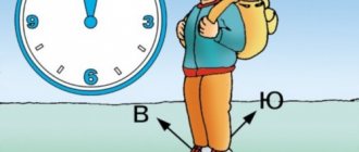
Greeting students. Good morning, the day begins, First of all, let's drive away laziness. Don't yawn in class, but work and search! Creating a friendly working atmosphere, Statement of a problem situation: The house was built in the south. Explain in which direction are all its angles?
teachers. Recall previously learned material
conscious construction of a speech utterance in oral form
Formation of a system of knowledge about the earth's surface
Use oral language to provide a reasoned answer
finding yourself in this situation. Let's discuss if there is a way out
navigate this situation and what you need to know in order to
Tell us in your own words: do we need this in life, if so, where? (Slide No. 2)
Enter into dialogue, speak out and realize
Choosing the most effective ways to solve problems depending on specific conditions and the ability to apply them in various life situations
Formation of a knowledge system about terrain orientation using a compass, map, knowledge of signs
Mastering safety techniques and terrain orientation
The ability to determine the success of completing one’s task in dialogue with the teacher; choose the most effective ways to solve cognitive and educational problems
items. Read the rules when working with a geographical map (memo to the student) (Slide 4) Show the directions on the area plan.
How is it usually shown? In what direction from the ferry on the Sot River is the dam on the Luch River? Determine how the direction of the Sot River changes.
How can you find out the direction of the horizon using a map?
Each side of the horizon has not only its own name, but also a digital number.
value – azimuth. Find information about azimuth and
slide azimuth of the sides of the horizon. Formulate a conclusion: How can you navigate the terrain, map, captivity?
Students in pairs work with a compass, atlas, determine the sides
Students work with the atlas (pp. 12-15): find and learn information
They work with a textbook, map and area plan: determine directions.
Students work with the textbook: find and learn information about azimuth, convey the content in their own words
Formation of communicative competence skills
Conscious construction of a speech utterance in oral form
Formation of the concepts of “orientation”, “sides of the horizon”, “azimuth”
Set educational tasks, choose the most effective ways to solve them
Be able to work with various sources of information, classify and generalize
Receive information as a result of semantic reading of the text
Perform motor actions technically correctly
This is interesting: Fishing rod for winter fishing, how to make a winter fishing rod with your own hands
2. Starting position: sitting on a chair, put your hands on your belt:
3.Starting position: sitting on a chair or standing:
1st move your left hand behind your right shoulder and turn your head to the left;
2- Raise your right hand behind your left shoulder and turn your head to the right.
Stage 5. Training activities to implement the plan. Expression of the decision. Application of new knowledge
Offers tasks for “new” knowledge, encourages students to theoretically explain facts and contradictions between them.
Let's practice determining the sides of the horizon. (Slide No. 6) From
Janeiro. What course should pilots keep to avoid going off course? Justify your answer. Invites students to talk about the results of their work. – Let’s test your knowledge of the sides of the horizon and your ability to navigate on a plane.
The teacher dictates according to the directions (2 cells to the east, 2 to the southeast, 2 to the northeast, etc.) What kind of figure did you get? (butterfly)
Discuss in groups and justify their choice of decision or disagreement with the opinions of others.
Students must mark the values with dots in their workbook to create a shape... of a butterfly.
Students formulate a conclusion about the need for knowledge and practical skills in orienteering
Willingness for self-education and self-development
Formation of skills to give a reasoned answer
perform an action according to a given pattern, rule
Communication skills training
Formation of communicative competence skills
Ability to avoid creating conflicts and find ways out of controversial situations
Formation of independent work skills.
Application of skills and knowledge when performing educational and cognitive tasks
Work in groups to solve a common problem
Communicate and interact with peers on the principles of mutual respect and mutual assistance, friendship and tolerance
2. Self-assessment of work during the lesson using the “Traffic Light” method: red – I worked well, I understand everything; yellow – I worked well, I don’t understand some things, it didn’t work out; blue – I worked well, but I don’t understand a lot, I didn’t happened. (Slide No. 7)
2. Compose a “Cinquain” based on the topic of today’s lesson.
asked questions . Explain, analyze, formulate.
Give a detailed answer, summarize the information, formulate a conclusion about the need to use orientation skills to determine your position in space
Constructing a speech utterance orally
Use oral language to provide a reasoned answer
paragraph/ No. 4 - in writing/. Optional: Workbook assignment No. 3 p. 25 (written) (Slide No. 8)
Using skills and knowledge to complete a task
Use a variety of information sources
The figure shows the relative position of the sides of the horizon and intermediate
directions concluded between them. Looking at the figure, it is easy to understand that for
determining directions to all sides of the horizon is enough to know only one thing.
Intermediate directions are used to clarify orientation if
the direction towards the object does not strictly coincide with the direction towards one of the sides of the horizon.
Using a compass, you can determine the direction to the sides of the horizon at any time
First, I note that when navigating the terrain, a compass is widely used.
Adrianova. Then I tell you about its structure using a compass.
Rules of circulation. To make sure the compass is working properly, you need to check
the sensitivity of its needle. To do this, the compass is placed motionless in
horizontal position, some metal object is brought to it, and then
cleaned up. If after each shift the arrow is installed at the same
reading, the compass is in good working order and suitable for use.
To determine the sides of the horizon using a compass, you need to release the needle brake and set the compass horizontally. Then turn it so that the northern end of the magnetic needle coincides with the zero division of the scale. With this position of the compass, the signatures on the scale N, S, E, 3 will be respectively.
From long-term observations it has been established that: the bark of trees on the north side is usually rougher and darker than on the south; moss and lichen cover tree trunks, stones, rocks on the north side; anthills are located on the south side of trees, stumps, bushes; their southern side is flatter than the northern; on coniferous trees, resin accumulates on the south side; During the ripening period, berries and fruits acquire a mature color on the south side; tree branches, as a rule, are more developed, denser and longer on the south side;
near isolated trees, pillars, and large stones, the grass grows thicker on the south side; clearings in large forest areas, as a rule, are cut strictly along the line
Expert opinion
Tarasov Dmitry Timofeevich
Master of Sports in mountaineering. Author of scientific articles on the topic of survival in the wild
North South West East; at the ends of the pillars there are numbers of forest blocks from west to east; altars and chapels of Orthodox churches face east, bell towers face west;
the lower crossbar of the cross on the church is raised to the north; on south-facing slopes, snow melts faster in spring than on north-facing slopes; The concave side of the moon, on the minaret of Muslim mosques, faces south.
Determining directions on the plan and map (working with the textbook)
In which direction from the ferry on the Sot River is the dam on the Luch River?
Determine how the direction of the Sot River changes.
Read the skills when working with a geographical map (memo to the student) (Slide 9) Highlight
How can you find out the direction of the horizon using a map?
Orientation on the earth's surface
To develop knowledge about methods of orienteering; ability to determine directions using a compass; the concept of “azimuth” and the ability to determine it
Educational Resources
Dronov V.P., Savelyeva L.E. – Geography. Geography. 5-6 grades Workbook by V. P. Dronov, L. E. Savelyeva, presentation “Orientation on the Earth’s surface,” compass, protractor
- How people navigate
- Azimuth
Personally significant problem
Methods and forms of training
Methods: partial search, visual, workshop, control
Forms: individual, pair, group, frontal work
Orientation, main and intermediate sides of the horizon; compass; Polar Star; azimuth