Geography is a discipline that allows a person to get an idea of what the planet is like. It makes people diversified, free to navigate the peculiarities of the location of countries, continents, continents, and natural areas. This is a very serious subject, the study of which must be given great attention in school. This will give children the opportunity to understand the climate in a particular region, the natural nuances of a particular area, and understand the location of reservoirs and other countries. All-Russian and international competitions regularly held on our website help test the level of knowledge in geography.
Aspects of Geography Competitions
Competitions do not require advance payment. They are intended for students in grades 1-11, distributed according to nominations and compiled on the basis of the school curriculum. Anyone can take part in competitions to test their knowledge of geography. Schoolchildren, under the guidance of a teacher, need to choose a suitable topic, do work on it, and then send it to the jury for consideration. The results will be ready within two days.
Students can take first, second, third place, or receive the status of laureate or participant. Winners have the opportunity to order a diploma or certificate, which is marked with an individual number, has personal data of the student, his geography teacher, and contains a record of the date of the competition and its results. The deadlines for completing the work are not limited in any way. There are also no restrictions on the number of places for winners. You can participate in such competitions many times.
The benefits of geography competitions for teachers and students
Participating in competitions is a fun and useful pastime without any stress. The diplomas received can be printed on paper and provided as an attachment as a teacher’s portfolio when receiving a new category. Documents are perceived as worthy evidence of a professional teacher and his desire to constantly improve. They open the way to a successful career, accompanied by an increase in the teacher’s material wealth and the respect of others for him.
Students who become winners of competitions can present such diplomas, certificates along with certificates when entering educational institutions related to geography. This will add points to them and cause a favorable attitude from the examiners. For children who are not yet planning to enroll somewhere, participation in competitions will help raise self-esteem, gain faith in their own strengths and the will to win. Such distance competitions are an excellent way to educate a child, able to give him new knowledge, organize him and force him to read a lot of additional literature on geography.
Examples of games for geography lessons
- Gaming technologies at different stages of the lesson.
Game moments can be used at different stages of the lesson.
The use of games in the classroom is very diverse. It can be organized at the beginning of a lesson when checking homework or to activate students’ attention, when studying new material for a deeper, more meaningful and faster assimilation of educational material, and at the end of a lesson to consolidate the learned material and relieve stress after difficult class work. The teacher chooses all these game forms depending on the topic of the lesson, the preparedness of the students, and their age. I give examples of some game moments.
In the 6th grade, when studying the topic “Plan and Map”, in order to lead students to study a new topic, I encrypt it using symbols. In this way, students repeat the topic “Conventional signs.”
m a s t a b
When studying the topic “Geographical coordinates”, you can encrypt a word using coordinates. Students must first determine which cities correspond to the given coordinates, and then determine the given word.
- 59 N. 11 east About the word
- 35 N. 51 E. Tehran _
- 13 S 76 W. Lima
- 52 N. 105 E. And Rkutsk
- north latitude 115 E. Ch ita
- 42 N 78 W NY _
- 46 N. 75 W. Oh tawa
This assignment can be given to students at home. They can encrypt their first name, last name or any other word, which their classmates will guess at the next lesson.
Geolotto.
In the lesson of testing and recording knowledge and skills, I use geolotto. To organize the game I use an aesthetically designed container. The container contains opening barrels containing thematic questions. In addition to the questions, the barrels contain a “prize” token and a “zero” token.
Questions for geolotto, which are placed in barrels, are prepared by the teacher and students. Questions can be on specific topics, training blocks, sections, or of a general educational nature.
Then the game itself begins. Students, at the request of the teacher, begin to take out barrels with questions. Then the barrels are opened, questions are taken out of them, to which the students must answer after a short period.
What are the advantages of lotto games over the famous frontal survey? The fact is that the student knows that he himself will have to decide his “fate”, i.e. draw out a complex or simple question. And the child will never feel that the teacher is deliberately trying to convict him of ignorance of the subject, or to give him a negative mark. The respondent is evaluated by classmates by expressing their evaluative opinions. When grading, I focus on strong students who really know the subject. If suddenly the grade is given by the students biasedly (or the children do not know the correct answer), the teacher explains the essence of the question, pronounces the correct answer and assigns the grade himself. If the student gets the “Prize” barrel, then he is exempt from answering, and if the “Zero” barrel is read, then the teacher has the right to ask the student any question at his discretion. With this game, an atmosphere of collegiality between student and teacher always reigns in the classroom; the game is accompanied by a high positive emotional background.
“Logic problem”
Logic problems are well known to puzzle lovers. They represent a series of conditions (statements) with the help of which the problem is solved. To do this, they usually create a special table containing all possible conclusions. Then, using logical reasoning, they place “+” and “-” in it, indicating correct and incorrect conclusions.
Exercise. Determine which ships the famous Russian navigators M.P. Lazarev, G.Ya. Sedov, V.M. Golovin sailed on, if it is known that:
1). The Saint Phocas was the last of these ships to be built;
2). At the time of the voyage of “St. Gabriel,” M. P. Lazarev and V. M. Golovin were not yet born;
3). V. Bering made his journey earlier than the others;
4). The ship “Mirny” took part in the Russian round-the-world expedition that discovered Antarctica;
5). G. Ya. Sedov took final exams at the Naval Cadet Corps together with his grandson V. M. Golovin.
In cells with unacceptable options, it is necessary to place minuses, and the remaining free cells will show which ship each of the sailors commanded.
| Navigator | “Saint Phocas” | “Saint Gabriel” | "Peaceful" | "Diana" |
| M. P. Lazarev | ||||
| G. Ya. Sedov | ||||
| V. Bering | ||||
| V. M. Golovin |
“Words in words”
The teacher writes a geographical name on the board, for example: “Karaganda”. From the letters of this word you need to create other geographical names without adding new letters, and the letters that are in this name can be used only once in one word. The letters of the word “Karaganda” can be used to form the following names: Canada, Angara, Ankara, Ghana, Karadag.
"Geoalphabet".
There can be several options in this game.
1. The game involves two teams. After the draw, one of the teams No. 1 starts the game. The captain of this team, by agreement with its members, asks 5 or 10 questions on geographic topics, and members of team No. 2 must give answers starting with one letter. The captain of the first team names the letter, for example the letter P.
1. Name a famous Russian traveler-geographer. Przhevalsky.
2. Name the country of our planet. Paraguay.
3. Name the capital of a European state. Paris.
4. What river flows in South America? Parana.
5.Name a city located on the Kamchatka Peninsula. Petropavlovsk-Kamchatsky.
6. Which peninsula in Europe do you know? Iberian.
7. What mountainous country do you know? Pamir.
8. Who headed the first drifting station “SP-1”? Papanin.
9. Name a channel you know. Panamanian.
10. What mountains are located in England? Pennines.
- Teams or pairs or each student individually can participate. The task is to name geographical objects or terms using letters of the alphabet. It is advisable to show geographical objects on the map, and give definitions to the terms.
For example. Atlantic Ocean – White Sea – Great Britain – Ganges River – Drake Strait – etc.
Azimuth – Barometer – Wind – Geyser – Demographics – etc.
Also, as a task, you can suggest listing the names of animals or plants, indicating the continent or natural area where they live.
This game can be used both at the beginning of the lesson and at its completion. Students must say “password” before taking their seats. Depending on the topics covered, these could be republics of the Russian Federation and their capitals, countries of the world and their capitals, names of seas, islands, etc. At the end of the lesson, students must say “password” to leave the class.
“Geographic labyrinth”
This technique is a type of test designed to consistently and carefully pass a set of true and false statements. Each statement has arrows labeled “YES” and “NO”. If the statement is true, then you should follow the “YES” arrow, and if it is false, then you should follow the “NO” arrow.
I will give as an example an assignment on the topic “Southern Siberia”. Annex 1
"The Third Wheel" or "The White Crow"
The teacher names 3 - 4 words related, except one, to a topic. Students must define the word and justify their choice.
For example. Koala, platypus, jaguar, echidna. (animals of Australia)
Syktyvkar, Arkhangelsk, Petrozavodsk, Yakutsk. (capitals of the republics of the Russian Federation)
"Geomail"
Students are given “letters” (you can use “SMS”) with a description of the natural area. The task is to distribute it to the recipients. Envelopes with the names of natural areas hang on the board. The tasks in this case can be varied: geographical objects of the continents, rocks, etc.
“Find it on the map.”
The teacher asks a pair of students to show a geographical feature on the map. The one who showed it first wins. The one who loses is eliminated and the next one takes his place.
"Yes and no"
The teacher (or leading student) thinks of some geographical object and gives a small hint. For example, that “it” is in Asia. Players must guess the object by asking yes or no questions.
"Clusters"
At the stage of updating knowledge, for example, when studying the topic “Flora and fauna of the African savannas,” students are asked to fill out a cluster on the board (or card).
Savannah animals
Birds ? Ungulates
? ostrich? ? ? a lion ? zebra giraffe
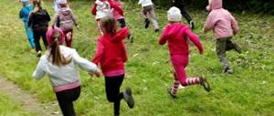
Recently, much attention has been paid to health-saving technologies. I offer several outdoor geographical games.
Game “Once! Two! Three!"
The participants in the game join hands and form a circle. Starting to move clockwise, they say the words: “One!” Two! Three! Call me the sea!” At the last words, everyone stops and begins to take turns listing the names of the seas. If anyone remains silent, he is eliminated from the game.
Playing with words: “One! Two! Three! The island (mountains, rivers, city), you name it, continues until the minimum number of participants remains.
Game “Latitude and Longitude”
The participants of the game (there must be at least 4 people) are divided into four groups. The first is “northern latitudes”, the second is “southern latitudes”, the third is “eastern longitudes”, the fourth is “western longitudes”. The players alternately line up. The presenter names any geographical object, and the participants in the game quickly remember where it is located. Those representing the “latitudes” and “longitudes” of this object should quickly sit down. For example, the presenter names: the island of Madagascar; guys are squatting, depicting “southern latitudes” and eastern longitudes.” Anyone who makes a mistake receives a penalty point, and if they make a second mistake, they are eliminated from the game.
Game “Up - Down”
The players form a semicircle from the leader. He begins to list states large and small in size. If a large state is named (China, Russia, Brazil, etc.), the guys rise on their toes and stretch their arms up, thereby seeming to show the size. If small states are named, all participants in the game throw up their hands. Anyone who makes two mistakes is eliminated from the game.
The presenter not only names the countries, but also performs the movements himself, sometimes making deliberate mistakes. Those who are inattentive and copy the actions of the leader will soon be eliminated from the game. The game can last 2-3 minutes, after which it can be repeated, but you must already name mountains, lakes, etc.
"Vane"
Used when studying the topic “Orienteering” or “Wind”. Several students come to the board and the teacher says: “The wind blows from the north.” Everyone should face south (i.e., away from the wind). Then: “The wind blows from the west,” etc. Or “Hurricane.” Everyone is spinning. "Calm". Everyone stands calm.