so UNT / Geography / Lesson plans for geography 11th grade
Lesson 11. Foreign Asia
08.07.2015 8097 0
The purpose of the lesson: to form students’ ideas about the peculiarities of the geographical location, the population of the region, the mineral resource base, and the main sectors of the economy.
Equipment:
· textbook;
· atlas;
· reference book “Socio-economic geography of the world”;
· educational electronic publication “Economic and Social Geography of the World”;
· handouts for the lesson;
· computers;
· projector;
· wall screen.
I. Self-determination for activity.
You already know that the whole world in which we live is divided into parts - regions. We have already met one of these regions. This is Europe, so it would be logical to consider the next region closest to the already known one.
· What region could this be? (Asia)
· Slide “Foreign Asia”
Really. This is the closest region in the world to Europe. But you can study it in different ways. You can mark the most interesting or most famous facts, the largest or most significant events and look for an exclusive. But to form a more complete picture, some other characteristics are required.
· What other indicators do you think we could use to evaluate the region? (Geographical location, population, mineral resource base, main sectors of the economy)
Today we are unlikely to have time to thoroughly understand these issues. But this is our first lesson on this topic, and subsequent lessons will provide an opportunity to get to know the region in more detail.
So what do we know about Asia?
Student’s speech with the results of a sociological survey (presentation)
In addition to the above, scientists say about Asia: (Slide “sayings about Asia”)
Which statements are considered close to the truth? You can't tell right away. We'll have to figure this out.
WORK IN GROUPS.
Each group has its own task (see appendix)
Presentation of research results.
1 group. Student presentations are accompanied by a slide show
· Slide “Features of geographical location.”
· “Subregions of Asia”
2nd group. Slides:
· Leading countries in terms of population
· Slide “Anamorphosis of population”
Asia has the highest average height on Earth - 950 m, the highest point of the entire Earth, the famous Chomolungma (8848 m), and the deepest oceanic trench - the Mariana Trench (11022 m). Asia - the deepest depression of the Dead Sea 9-395 m, in Asia the deepest lake in the world is Baikal (1642 m).
But what about the region’s mineral resource base?
3 group
· Slide “Natural resource potential of Asia”
4 group
· Slide “Industry of the region”
So what do we get? What can you conclude about the statements you read at the beginning of the lesson?
· Slide “Sayings about Asia”
· Slide “The 21st century is the century of Asia!”
Musical break (Chinese music)
Well, what about Europe? Or will she never regain her leading position?
Let's compare these regions according to the Human Development Index (reference book, page 16.)
· Slide “Human Development Index”
· Countries in which region of the world occupy leading positions? Examples of countries.
· Where are the Asian countries? Why?
Asian countries use ready-made successful developments and innovations, the creation and implementation of which were mainly carried out by European countries through trial and error.
Asian countries are at the industrial stage of development, and European countries are at the post-industrial stage.
· Where is Russia?
It occupies an intermediate position between European countries and Asian countries. And this is not surprising - after all, one part of our country is European, and the other is Asian!
Thus, our statement that the 21st century is the century of Asia turns into a question. And we will look for the answer to it in the following lessons.
· Which countries would you like to explore in more detail? (Japan, China, India)
Homework.
· Textbook text: Topic 7 paragraph 1
· Plot the subregions of Foreign Asia on a contour map
· Complete tasks in groups
RESULTS OF THE LESSON.
Questionnaire (if the answer to the question is positive, students stand up, and if the answer is negative, they sit down in their seats or do not stand up at all)
1. Has your understanding of the region changed?
2. Do you want to know more about this part of the world?
3. If you have the opportunity to travel, will you visit Foreign Asia?
APPLICATION.
TASK FOR GROUP I
EXERCISE. Using the textbook text (topic 7), continue the sentence:
The main features of the economic and geographical position of the region are:
1. _______________________________________________________________________
2. _______________________________________________________________________
3. _______________________________________________________________________ .
EXERCISE. There are several subregions within Foreign Asia. Using the educational electronic publication (Regional Review - Foreign Asia - Regions), indicate what these regions are and what countries make up them. Fill the table.
TASK FOR 2nd GROUP.
EXERCISE. Using the flyleaf of the textbook, determine which countries are the leaders in population in the region. Write them down in descending order of population.
| A country | Population (million people) |
Compare the list of resulting states with the ten most populated countries in the world. Draw a conclusion.
TASK FOR GROUP 3
EXERCISE. Using the reference manual (pp. 46-65), evaluate the mineral resources of Foreign Asia and list the main types of resources, in terms of which Asia occupies a leading position.
Draw a conclusion about the region’s supply with basic types of raw materials.
TASK FOR 4 GROUP
EXERCISE. Analyze the map of the educational electronic publication (Foreign Asia - Industry), and write down the names of the industries that are developing most dynamically in the region.
What changes do you think will occur in the near future with these sectors of the economy in Asian countries?
Homework.
Group 1
Assignment: Give a description of the geographical location of the country according to the plan:
| Plan | Composition of actions |
| Name Geographical position | 1. Name and show the country and its capital on a political map. Read the "business card" 2. Apply the technique of determining the territory's geographical area, indicating the position on the mainland, border countries, position in relief conditions, climatic zones, river basins of natural territorial complexes |
Rate the geographical location:
| Favorable features of EGP | Unfavorable features of EGP |
Group 2.
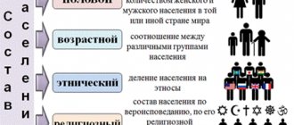
Exercise. Using various sources of information, fill out a table characterizing the country's population.
| Population traits | Brief answers |
| 1. Number and place in the world in terms of population | |
| 2. National composition of the population | |
| 3. Religious composition of the population | |
| 4. Population distribution | |
| 5. Urbanization | |
| 6. Form of government of the country | |
| 7. Administrative - territorial structure |
Prepare reports on the history and religion of the country
Group 3
Assignment: Using atlas maps and the text of the textbook, divide the natural resources that the country is rich into into groups. Write your answer in the form of a diagram.
Question: Do you think natural resource potential contributes to the development of the country or hinders it?
Group 4.
Assignment: Prepare reports on the topic “The most famous trademarks of the country”